Video Tutorial 2 - Modulo
this video tutorial looks at reducing the number of imported GPS points by selecting only every 5th point. Still have technical issues with the sound, but we are getting closer.....
Friday, November 03, 2006
Sunday, October 22, 2006

Do Not Pay for Free Data many thanks to Glenn and his GIS Data blog that focuses on where to get free geographic data via the web. It is well organized and a required stop before I start any project. Keep up the great work Glenn!
Friday, October 20, 2006
New! Video Tutorial - Excel to ArcGIS 9.1
Since sending video over the web has not only become extremely simple, but almost the new standard, we've decided to produce our very own ArcDex GIS video tutorials. This first video goes through the steps of connecting an Excel spreadsheet to ArcGIS 9.1. The intent is to help us all appreciate the new Excel functionality in the upcoming 9.2 release :).
I'm not too happy with the way the flash video distorts most of the desktop images. In the future maybe I'll try Quicktime format instead, but for the sake of considering the fact that not everyone has Quicktime installed, let's see how this works out.
Thursday, October 12, 2006
Laguna Beach Map Remix
For ArcDex's 50th post celebration I thought I would work on something that is not so 'dry' of a topic. So, after thoroughly enjoying several Subway Map Remixes on Boing Boing, I thought it would be interesting to take it from Subway mapping to street mapping. So I grabbed my ESRI data CD and focused in on Laguna Beach, California (and why not, the Real OC is one of my favorite shows for some unspeakable reason).
Using Wordsmiths anagram engine I set out to rename a majority of the names of LB streets. While going through these, I found some shockingly relevant phrases coming to light. Phrases relating to the war and tensions in Middle East, for example, Oman Did (Diamond St), Octane Visa (Ocean Vista Dr), Iran Mock Corny (Rim Rock Canyon). And the most sinister phrase I found: Iran Bush GoGo (Gainsborough). Could the secrets of today’s political scene deepest questions lie in the streets of the Real O.C?
I was also amused by some of these: Blue Bird Canyon is an anagram of Crabby Oiled Nun, while Canyon Acres could Scare Any Con(servative?) perhaps?
A full version in PDF format can be downloaded here (its big - 36x48)
Download the shapefile for the remixed roads here (zip file, remixed names are in field N9)
Note: Some phrases may be objectionable to some readers. Keep that in mind.
Tuesday, October 10, 2006
Maps of War: 3000 BC to 2006 AD
I didn't really pay to much attention to European History in High School. So I'm thankful for this quick review from the Maps of War Imperial History video.
I am really hoping that the ArcGIS 9.2 release can handle this kind of video as well.
Friday, October 06, 2006
Using Google Code Search for ArcGIS![]()
Google Labs has recently announced the unveiling of its' newest creation - Google Code Search. Code Search indexes publicly available code - which is then available to you via their search engine. This should be very helpful for all you custom programmers out there.
I tried out the simple query of ArcGIS and got back a couple of interesting results. One of which being a Python script for exporting the ArcGIS table out to mySQL. Right above that result was a script written in C that creates cartograms.
Have any better ideas or search strings that will maximize the use of Google Code Search in GIS? Please share them in the comments section.
Wednesday, October 04, 2006
Massachusetts Tollbooth Locations in Google Earth
One of the best government GIS sites has to be the State of Massachusetts MassGIS portal. They have a ton of shapefiles for almost anything you could need, plus building footprints for the city of Boston. Here is a Google Earth KML we file created from the MassGIS 'Tollbooth' layer which shows the locations of interstate tollbooths in the Bay State. 
By providing this kind of base data, it allows for anyone to create additional value added products. By displaying this in Google Earth, we can share the shapefiles with users that would never load a true GIS package.
What experience have you had with other States? Perhaps you could share your info in the comments section.
Shapefile Source: Office of Geographic and Environmental Information (MassGIS), Commonwealth of Massachusetts Executive Office of Environmental Affairs
Tuesday, October 03, 2006
Increasing Federal Markets for GIS
The Federal Government has been a huge GIS consumer for years. That’s no secret. They are one of the few agencies that can afford a full deployment of GIS software. But it’s good to see that they are continuing to rely on and emphasize GIS and spatial technology. The “Google Earth Effect” seems to have permeated the newest transportation re authorization bill and other planning doctrines. This new bill requires that visualization takes place during the planning stages of a project. And the bill specifically mentions using GIS to show what the project would look like after it is built.
The FHWA and the FTA recognize that there are myriad ways to use
visualization techniques to better convey plans and programs and there
are wide variations among MPO capabilities and needs, especially
between large, established MPOs and small, new MPOs. States and MPOs
may use everything from static maps to interactive GIS systems, from
artist renderings and physical models to photo manipulation to computer
simulation. Visualization can be used to support plans, individual
projects or Scenario Planning, where various future scenarios are
depicted to allow stakeholders to develop a shared vision for the
future by analyzing various forces (e.g., health, transportation,
economic, environment, land use, etc.) that affect growth.
Tuesday, September 26, 2006
Global Competitiveness Report in Google Earth
Here's another Google Earth file with some current geospatial data. The World Economic Forum has released its 2006/2007 report which attempts to model the process of growth using all the complicated factors that affect countries. The U.S. has slipped. From 1st to 6th based on war and security spending.
If you already have Google Earth installed, check out the data by clicking HERE.  ken@stolasgeospatial.com
Saturday, September 23, 2006
Weekend Video - Man Behind the Maps Part II.
2nd installment of Billy McWilliams doing his part to keep Google Maps up and running.
Friday, September 22, 2006
National E. coli Reported Cases Map in Google Earth
The FDA continues its crackdown on fresh spinach in hopes to bring an end to the current E. coli H157:H7 outbreak. On 9/21/2006 they released the number of illness reports per state.
We've created a simple thematic KML layer showing the number of reported cases per state for a client. Click HERE to open the KML file in Google earth to see the breakdown data (you must have Google Earth installed.)
E. Coli | Spinach | FDA | Google Earth
Wednesday, September 13, 2006
Geographic Spellcheck Strategy
I've grown tired of my Word spell checker constantly showing red underlines on my street names in Office documents. It would take months to type in all the road names into the dictionary if I wanted to use them during spellcheck. Then I realized I had a entire database of street names right in my shapefiles.
So I set out to create a Word custom dictionary in these steps:
1. Save out the road centerline file to DBF.
2. Open the DBF in Excel and delete all the columns but the road name.
3. Save As Tab Delimited.
4. Open in Word and make case changes (if necessary).
5. Copy the data into a Wordpad file. Save with a .dic extention.
6. Load the custom dictionary in Word! Viola!
Now I think I am going to do waterbodies, rivers, railways, airports, etc.....
Tuesday, September 05, 2006
Concept "Maps"
O.K. So these are not true geographic maps, but I think the design can be applied to cartography just the same. Applying some of their principles when presenting Metadata or Schemas would make for an awesome display board.
We develop a range of diagrams and maps to create, test, and refine architectures or organizational structures for the applications and sites we design. Maps created as design tools serve many of the purposes of maps created during audits — creating shared models for the team, uncovering problem areas, and serving as a reference for product managers and engineers.The examples come from Dubberly Design Office, via LifeClever. They are really sharp!

Monday, August 21, 2006
Trimble GeoXT Note
Well today I dusted off my trusty 'ole Trimble GeoXT. Unfortunatly, it's been mothballed since December. Just didn't have any projects for it.
Well when I fired it up it went into some kind of mandatory 15 minute charge up mode. After that, I tried to start up ArcPad 7. Nothing. Couldn't find it anywhere in the system. Well, it took a full re-installation and sync to get back up and running.
Not sure what the technical aspects are of this, but I'll never let this thing get that run down again. Now I'm headed outside (finally - it's 75F and breezy.)
Wednesday, August 16, 2006

After geospatial blogs were totally overlooked at the ESRI 2006 Users Conference, I was excited to see that there would be an article about such blogs in the Jul-Sep 2006 edition of ArcUser magazine. But, in the end, I was un-fullfilled (once again :) ).
I think the main reason for this disappointment in the article was the discussion of the extreme basics of the technology that bring us blogs, and not focusing on content. On page 30 we are talking about object model diagrams and cursors for arcobjects, then we move along the line a couple of pages to the definition of a "podcast???" Consider your audience here. And good luck finding something on PubSub - use Google Blogs or Technorati search engines to find something useful.
Lastly, the authors only plug their own website and like one or two more (3 of which are aggregators and not blogs). Not that the following blogs need any plugs, but here are a few that I thought would be no brainers to talk about or maybe even get interviews with:
Tuesday, August 15, 2006
ESRI Tools At Different License Levels
One thing that drives me crazy is forgetting that I have ArcInfo and then distributing models to ArcView users who cannot use them. I really wish there was some type of color code on ArcToolbox that would remind me that its a ArcInfo only tool. Well until that happens, I've been using this file from the Online Help.
You may also find it helpful.
Monday, August 14, 2006

Where 2.0 Conference Presentation Files
The presentation files (PPT) are now up at the Oreilly Where 2.0 conference held back in June 2006. There are alot of good topics that I am saving for review, after I try out some of the new tips and tricks learned at the recent ESRI UC. Can't absorb too much in such a small time frame!
Saturday, August 12, 2006
It's a Wrap - 2006 UC
Well the curtains have come down once again on another ESRI users conference. Overall, I think it went great, but the format and topics are getting a little stale. Kudos to the San Diego Airport TSA staff - when we got to the airport at 9AM there was NO ONE in line for security! I am sure we all were thinking about the world events as we flew out on Friday. I felt very safe without being inconvenienced.
There are a couple of wrap up items out there you might want to check out:
- James Fee's reflections on the conference
- A new Video Blog emerged called GIS Nation - <
> - What's new in ArcGIS 9.2
- ArcGIS Explorer movie demo
- ESRI Touchtable Demo
- Be sure to register for a 9.2 demo in your state here
Wednesday, August 09, 2006
2006 UC Photos....
This photo is of the 1/4 scale elevation map of British Columbia. Glenn over at AnyGeo has a good write up about it. Seeing the natural curvature of the earth on this display makes it a must!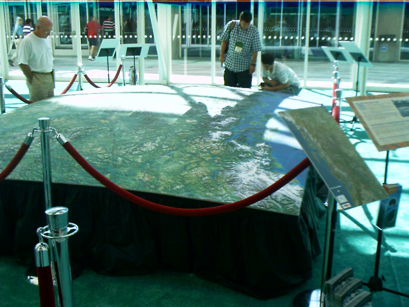

Tuesday, August 08, 2006
![]()
Animation Tools in ArcGIS 9.2
Live from the UC conference here in San Diego, I just watched a great demonstration using a new tool called Animation. The demo just showed population change over time in the northeast portion of the United States. Now instead of having to print out maps for each decade, the symbology changes as the values change. The animation can then be exported out to mov or avi's.
I can imagine that over the course of a year, this will be a tool that is greatly utilized for Planning Commission meetings, and the such. I went over to the ArcGIS Explorer display to see if they could take in Animation features into Explorer, but the answer was no.
Tuesday, July 25, 2006
Google Earth Effect
Today the All Points Blog featured a column in the Belfast Telegraph talking about satellite photos of a Pakistani nuclear reactor under construction. But it wasn't disclosed by some secret defense analyst, the images were found on Google Earth.
APB notes that the article makes mention of the "Google Earth Effect" popping up in several places around the web. I think that this so-called 'effect' is just viewers seeking consumer level aerial photography, and in a hurry. There will come a time when images used in the media will be near-real time, to include before and after scenes like those in the Katrina analysis.
But this GE Effect will not lead more users to embracing commercial GIS. I am sure that people don't realize that GE is the MS Paint of the GIS world.
And I don't know why the media isn't ready to start doing real time geostatistical analysis on the air. Here in Michigan, they proposed a making it a rule making it illegal for a convicted sexual offender to live within a 1000 foot buffer around a school. Sounds great on its face. But when I threw a quick 1000' buffer on a map around schools in my area, I realized it only affected about 10 homes around the school: and a rule like that would be theoretically ineffective. But I guess that wouldn't be a popular position to take.
Friday, July 21, 2006
US Panoramic Maps from the 1800's
The folks over at b12 Partners led me to a huge resource of historic panoramic maps from the Library of Congress. These 1,726 bird eye view maps (oblique angle) are available here. Many are availble for download in JPEG2000 or MrSid. Atlantic City, 1880
These maps really make me miss the old days of truely artistic cartography.
TAGS: maps \ GIS \ History
Thursday, July 20, 2006
Boston's Big Dig a Big Headache for Online Maps
Wow! This has to be the first piece of 'bad' press against the online mapping community. :) Although it really isn't a bad thing, I don't think anyone expects 'live' maps (yet). But the Boston Globe is documenting TeleAtlas' frustrations in keeping up with the constant ramp closures and reconfigurations.The Big Dig has long been a hassle for the online mapping world, with so many shifts and openings that the mappers can't keep up. Two years after the main Interstate 93 tunnels were fully open, online maps were having a hard time catching up. They still are.
TeleAtlas is also not releasing some data, but consumers won't use it quickly enough. So is the data coming in too fast? cool.
I believe we will probably not put the most recent data in, because 98 percent of customers will not be consuming it on time," said Al Cooley, senior director of global product marketing at Tele Atlas.
GPS \ Google Maps \ GIS \ News
GeoTagThings.com & Introducing GeoLibro.
First, I would like to introduce a very informative blog that I have been reading the past couple of days: Geolibro. Geolibro is published by the Purdue University GIS Librarian. I am finding that the best info is starting to come out of these academic blogs, as opposed to some commercial resources. I mean wouldn't it be great to just be able to research GIS all day!
Geolibro has a great write up on a new website called Geotagthings.com. He writes:
Am I slow? I just heard about Geotagthings.com, and it appears to be yet another boon to those interested in writing their web content to geospace. I guess we could call it geobookmarking, where we (users) organize our world of web content by how it’s organized across the planet. The concept isn’t wild here, but I’ve played with this tool for about ten minutes (What? I get excited.) and it is very easy to tag your web content. You save a bookmarklet to (probably) your bookmark bar and whenever you come across a web page that you want to tie to a place, you just click that bookmarklet. You’re then taken to the geotagthings site, where you verify the location, add an optional note, then complete the tagging process and return to the original website.
ArcGIS 9.1 Service Pack 2
Just a general announcement in case you haven't heard, but SP 2 is out for ArcGIS 9.1. Direct Link.![]()
Monday, July 17, 2006
Science On a Sphere (r)
From the NY Times and Computers, Society, and Nature blog, comes a story about NOAA's Science On a Sphere project.
"Science on a Sphere takes flat, two-dimensional images and data taken from spherical objects like planets and moons, and synchronizes and blends them into animated presentations. Most of the almost 100 presentations created so far are silent displays meant to illustrate lectures."
What's more exciting is the authors immediate thought that GIS data could be overlayed on these spheres:
"The specs state that the software accepts most graphics formats, but these are static .gifs, .jpegs, etc. Integrating the system with a GIS platform would allow the user to add/modify layers and create annotations on the fly (think of a sketch map, except rotating and 6 feet in diameter). I’ve simplified some of the details, but it’s doable."
Check out these simulations at the NOAA Site.
I've decided I want ArcGIS Explorer to have a hologram function now :)
Friday, July 14, 2006
ArcGIS on Mac OS X
Mac users - check out this post from c. spanring who is running ArcGIS desktop on his Mac.
What did he do?
Well, first I had to decide which virtualization software I want to use. Basically I had a closer look at Apple’s Boot Camp and Parallels Desktop. Whereas Boot Camp doesn’t count as virtualization tool. It just enables booting and running Windows on any Intel Mac. That was mainly the reason why I didn’t go with Boot Camp. Every time you need Windows-only software you’ll have to restart your machine. In the case of ArcGIS I’m not planning to use it on a 10 hrs/day basis on the laptop, it’s just an “emergency” install, to edit and modify some minor things on the way or to use it for presentation and demo purposes. So in the end I downloaded and installed Parallels Desktop.
There are of course some other tools available, like Virtual PC for instance, but after a quick research on some reviews I decided to focus on Boot Camp and Parallels Desktop for my purposes.
TAG | GIS
Thursday, July 13, 2006
Google Maps Mania on Call For Help Video
Mike Pegg talks with Leo Laport about Google Maps Mash-ups. Pegg and Laportes sites are daily visits for me.
Map of North American Internet
The folks over at the CIO blog have released a map showing the North American internet backbone. It includes every one of the 130,000+ registered routers, and is color coded by company.
In order to build this map Ches fired off 300,000 messages to various points on the Internet and mapped how they got there, recording the address of every router his packets passed. He also had to figure out a way to isolate routers in North America. The map is not perfect – he probably missed a few points and maybe double counted a couple more – but for all intents and purposes this is what the North American Internet looks like.
PDF version
in other news......
I wish I used Wordpress to make this blog
Monday, July 10, 2006
1906 SF Earthquake Simulation
Here is a new update on a major historical event. The USGS has recreated the 1906 San Fransisco earthquake. Movies include local views of shaking intensity from as far south as San Jose, running north to Santa Rosa.
This is a phenomenal use of geospatial technology.

Juicy Geography
It's a site in the UK with a sexy name for what most people feel is a boring topic! But Juicy Geography is a terrific resource if you need to teach a group about geospatial or GIS. I know the frustration of having my boss ask me to "do downstairs and teach so and so GIS." (After all, I only had 2 solid weeks of college level course work in projections alone, so this should be simple!)
So I look for help on the web. And JG has got it. Juicy has an awesome Google Earth mouse pad that can be downloaded and laminated as a quick reference sheet, powerpoint presentations, and unique geographical decision making process games.
Wednesday, July 05, 2006
2006 UC Has More Meat
I'll admit that after attending the ESRI UC year after year, the technical workshops garner less and less of my attention. I've found the most benefit from heading downstairs and working on specific issues with developers in the ballroom. But looking over this years agenda, I see that alot more programming and unique content has been added to the platter. These are the presentations that I'm not going to miss:
ESRI Developer Network: Advanced ArcGIS Engine for .NET Developers
ArcIMS: Optimizing Your Map Configuration Files for Better Performance and Display
ArcWeb Services: Developing Flash and SVG Mapping Applications
ESRI Developer Network: Customizing ArcGIS Desktop with VBA
I'm also interested in how they are going to address questions regarding the delays in ArcGIS Explorer?
Tuesday, June 13, 2006
Huge Announcement from Google
Google is very close to offering international geocoding through the API! Check out this post from todays Google Maps Mania Blog....
- International Geocoding Support - Google Product Manager Thai Tran just announced geocoding support for the Google Maps API. It is now available for US, Canada, Japan, France, Italy, Germany and Spain -- Convert addresses to geographic coordinates! This is a HUGE announcement for the Google Maps community who today might be using external geocoding services. He pleaded with the geo developers in the room to "promise to cache your geocodes" so they can up the standard number of geocoding requests available. Check out more info at the Google Maps API page for more details.
Thursday, May 11, 2006
Portable PDF Maps Free Web Seminar
TerraGo Technologies is gearing up for a free webcast on its map2pdf product on May 18th, 2006. I've used the software in trial version and its one of the best concepts to produce portable maps I have seen. Map2pdf creates PDF documents of your GIS data, complete with attributes, lat & long, and allows you to turn on and off separate layers. This enables you to share maps across the organization without using up valuable ArcGIS Desktop licenses, or when you are disconnected from a floating network key.

Register here for the seminar.
Thursday, May 04, 2006

Geographic Imager - a Photoshop Plug-in
For you photoshop users out there, Avenza Systems has recently released an update to its' Geographic Imager suite. Geographic Imager adds geospatial tools to Adobe Photoshop to allow for manipulating, editing, reproject, and work with geotiffs. Looks like an excellent way to enahnce those aerial photos for special studies. The extention is $599, but there are free trials available for download.
Tuesday, April 25, 2006
shp2text - Export your SHP's to Google Maps
Who isn't looking for an easy way to distribute SHP files to non-GIS users? The guys over at Obviously.com have a real quick way to do just that. Check out their ideas here. Its all based around the Shapefile C Library V1.2.
Thursday, April 20, 2006
Free WebCast: Pliable Display Technology (PDT) by IDELIX
This free webseminar looks very interesting and could have tons of applications. From their website: Pliable Display Technology (PDT) by IDELIX is an advanced user interface technology that can be integrated into new and existing software applications to improve the way users view and interact with data. Taking the shape of a "virtual lens," PDT provides multi-layer data viewing and data fusion capabilities, allowing users to work with rich, converged content more effectively and with greater ease of comprehension. Available in a Software Development Kit, PDT is easily integrated to enhance existing software applications' toolsets. PDT works on all forms of data from satellite imagery to text and video, and on all platforms from PCs to smart phones. Already proven in applications built for the National-Geospatial Intelligence Agency, PDT can improve the data visualization and interaction capabilities in your software offerings - join the Carahsoft Webcast for a demo.
Tuesday, April 18, 2006
Google Earth Creating a Placemark Tutorial......enjoy while we all wait for ArcGIS Explorer to be released
![]()
Using Mapdex.org to View Spatial Data with or without ArcGIS
ArcIMS services are great. There are terabytes of data from Iraq, NOAA, and Federal as well as local communities. But you are not limited to only viewing that data from within the IMS site. You can easily add the data you need right in ArcGIS!
It gets even better for those users who don't have ArcGIS, because mapdex will display the information directly into Google Earth.
First navigate over to mapdex.org. There is a good chance you will find something of interest, as the site claims to be:
"A global index of 2,067 servers, serving 37,178 map services, containing
over 400,000 GIS Layers, covering more than 4,000,000 columns"
Once you find your data, click the "layer viewer" icon. A overview window will show a sample of the data and provides an option to display in Google Earth. However, hope it contains a projection - otherwise it cannot be displayed in Google Earth. This is a good place to remind us all about projecting our own data whenever possible. As you will find out, you will find valuable data, only to be frustrated that you cannot display it because it is not projected - it's just good practice to add a projection.
Now, let's bring this same data into ArcGIS. First, jot down the server name. I want to catch up on some locations that Seth and Summer have been this past week in the Fox hit the O.C. So, it's off to Newport Beach, California!
One result comes up. The data I am looking for is at www6.city.newport-beach.ca.us, (the city's IMS site.)
In ArcGIS:
Select 'Add Layer'
In the Lookin Drop Down, 'Select GIS Servers'
Double click 'Add IMS' Server
Paste in the URL from above
After a moment, the server will appear in the window
Click on the data you want in your map and select ok.
You map now has a live connection to the O.C.!
Note: this does not work with sites that require a user login feature, so results may vary.
Friday, April 14, 2006
Google PHP Mashup - Hotels for UC
That time is upon us again, and hopefully you have already made your reservations in sunny southern California for 2006 ESRI User Conference. I wanted to take this chance to show an easy Google Map that I made. It really just took the amount of time to type in the addresses of the hotels listed in the back of 2006 UC guide. And then another map was born!
What made it so easy is the PHP script called Phoogle Maps 2.0 by system7designs. Once I uploaded the phoogle.php script, I customized my main page script with just my unique Google API key, and added in the hotel addresses. Thats it! Phoogle Maps uses the Yahoo engine to geocode your addresses, and then plots them on the map on the fly.
I havn't been able to fix the Firefox 1.5 glitch in the info window, as I am not a PHP programmer. But the maps looks great on IE (not that I condone using IE!). There is a noticiable lag while the points geocode. Check it out:
Thursday, April 13, 2006

GEOSPATIAL21.org Portal
In an effort to increase geospatial awareness, Geospatial21.org is a useful resource for any geospatial professional, however it is geared towards students. Developed by KZO Media with a $1 million grant from the Department of Labor, the site features videos, training modules, and offers a Geospatial Generalist Certificate for those passing a validation exam.
Tuesday, April 04, 2006
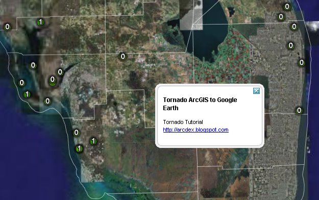
ArcDex Tutorial - Display Your ArcMap Data in Google Earth
Looking for a free, lightweight ArcMap extention to plot your ArcMap data in Google Earth? This tutorial demonstrates a quick project showing recent tornados in Florida, and just might be your answer.
Download the final product here to skip the tutorial and see the data in GE.
Monday, April 03, 2006
![]()
Google Maps moves to version 2 (officially)
Google has announced that it has moved over to version 2 today, April 3rd, 2006. Some new features include:
- Much smaller JavaScript download
- Two additional satellite zoom levels
- Overview map control
- Custom map controls
- Custom map overlays (GOverlay)
- Fewer memory leaks and more
Friday, March 31, 2006
![]()
DataPlace
I just made a couple of maps on the DataPlace.com webpage, and am pretty impressed with the vast amount of free information! They have a wealth of demographic info that can be shown on a map or on a chart, including: mortgage values, high income mortgage applicants by race, types of loans, rental attributes, income and employment, and building permits - to name just a few.
The interface is very similar to that of Google Maps. It is a bit more clumsy, but is easy to navigate and refreshes quickly.
If you are looking to do a free market analysis, this is your site.
Thursday, March 30, 2006
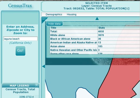
Census Trax Flash & Google Map
Yesterday, GeoGraphs and Urban Explorer announced the beta release of their CensusTrax application. Using Flash and Google Maps, a mashup is created that displays relevant demographic information in a slick transparent window.
The site is currently in Beta and open free of charge. However, it only features the State of California. There are plans to charge a nominal fee for the service in the future. (editors note...the Google Maps TOS forbids charging for a service that uses google maps, so it will be interesting to watch this develop.)
A description from their webpage states:
"Census Trax is an on-line interactive web GIS service to quickly retrieve, map and export US Census data. It will be available as a very inexpensive on-line subscription service in the near future. For now, while it is still in this beta version, it is freely available to anyone who wants to use it. "
Thursday, March 23, 2006

GIS Cookbook
The GIS Cookbook is a collection of simple descriptions and illustrations of GIS methods written with minimal GIS jargon. Recipes cover two GIS software platforms, ArcView 3.x and ArcGIS 8/9.x. The target users are social scientists with an interest in introducing spatial thinking into their current research and also having some experience with computers but little to no exposure to GIS. The GIS Cookbook is in its beginning stages and will be expanded to better serve the needs of social scientists.
This is an awesome concept. Using a simple and light interface, the folks over at CSISS.org have step by step tutorials relevant to daily GIS tasks. A great resource.
Wednesday, March 22, 2006
Awesome Google Maps Firefox Extension.
Tools continue to keep popping up everywhere - this one is for Firefox users with the Greasemonkey extension. Greasemap is a user script that resides in your browser and watches for street addresses in the webpages you browse. When it finds one, it instantly plots it onto a Google map in the top of your FireFox browser!
If you have never installed a greasemonkey script before, its easy. First, download the GM script here. Once it is installed come back to this page.
Right Click on the Greasemap hyperlink above.
Select INSTALL User Script.
Lets post ESRI's address here for instant gratification:
ESRI
380 New York St
Redlands, CA 92373
380 New York St
Redlands, CA 92373
Refresh your browser. Cool, aye?
Anytime a page like this that contains an address, a Gmap will appear on the top of your browser, address marker and all! If it gets to be bothersome, simply turn off your greasemonkey by right clicking the little monkey icon in the bottom right corner of the screen. He'll frown in sadness, but the maps will stop.
Monday, March 13, 2006

GEOINT
The Winter 2006 edition of Imaging Notes is out, and features a write up on ArcGIS Explorer from a geographical intelligence standpoint. It shows an excellent example of a vegetation vector layer taken right off of the Geography Network. The article is not directly readable online, but their feature story is.

David Maguire has prepared an excellent overview the explains some of the functionality of the ArcGIS Explorer application over at his blog GIS Matters.
A couple of items of interest include:
- It will also be possible to view ArcIMS and OGC WMS services.
- Some more detailed and specialized services will be available for a fee.
- A new set of explorer services has been added to the Server core so that anyone (with ArcGIS Server) will be able to create and publish a service.
Friday, March 10, 2006
Google Earth has struck up a huge wave of interest in GIS and spatial mapping capabilities. Most users of GE are not yet aware of the tremendous additions the GIS industry is going to add to this new wave in spatial information - but I am sure that ESRI's ArcGIS Explorer is going to change all that.
Market forces are working their magic. ESRI products are superior to most, (and because of that) they are able to charge practically whatever they like for their products. It took a mammoth search engine giant (in Google) to stir the pot a bit in the geospatial industry, and ESRI responded by cooking something free up.
Soon, everyone will be performing spatial queries and analyzing statistics of our own data using ArcGIS Explorer. We'll also be using other's data. The spirit of ArcDex (short for Arc Index, and inspired by MapDex) the theory that we all have shapefiles that can be shared among all users . We all have cool tips, tricks, and hints to make ArcGIS Explorer fun and useful. I hope to feature and catalog as much of this information as possible, to encourage a broad range of collaboration.
Subscribe to:
Posts (Atom)