Portable Marine GPS
A GPS is a global positioning system and perfect for navigating your course whether you are in a large or small marine craft of which the Garmin GPSMap 276C Portable,
Marine GPS, Automotive GPS Plotter is a prime example. The GPSMap 276C is an automatic navigator and chart plotter it has a built in auto route baseman that is made even better with Garmin’s marine cartography.
This portable marine GPS
unit supports external NMEA water depth, water temperature and water speed sources by means of two serial interfaces. The GPSMap 276C also has a CDI or course deviation indicator which is a tool that is normally found only on aircraft navigation systems. However, this works well in a marine environment and most especially if a boat has veered off its course.
The GPSMap 276C can also be used for navigation on roads and freeways as its Auto route baseman contains all the major routes, optional extras include map source city select software, data card, friction mount and 12 volt power adaptor. A speaker allows drivers to receive directions to addresses that are voice prompted turn by turn. The software on this unit is easily updated and has a fast USB PC interface; it is powered by rechargeable lithium battery packs or by a standard 230 volt AC plug. The battery offers five to fifteen hours of use depending on the settings of the backlight.
This unit has a 3.8 inch diagonal, 480x320 pixel, and 256-color TFT screen with an LED screen that is back lit. The dimensions of the GPSMap 276C are 5.7”wide x 3.2”H x 1.9” Deep with adjustable marine mounting brackets. This comes complete with adjustable quad helix receiving antenna with remote antenna capability. The built in base map allows for automatic routing and directions that are given turn by turn. The unit also provides separate serial and USB interfaces – and for easier viewing during the night a blue chart night mode – and a large numbers option for generally easier viewing. The unit accepts
Garmin GPS data cards as well as pre-programmed data cards. The GPSMap 276C also provides built in tide tables and celestial tables for sun and moon calculations for those who are interested.
Tuesday, March 11, 2008
Monday, March 10, 2008
Geo Whats? Monograms for Mountains
They are not created by space-beings or plasma vortexes. And no pranksters spent the entire night mashing corn stalks to create these designs. Rather, these are 'mountain monograms' and are a land-vanity marker of sorts that are quite common across the United States.

Also known as "geoglyphs" - there are thousands of these gigantic emblems carved into the country side. A leading resource for these monograms, Geoglyphs.org features hundreds of these features and the stories behind them. Geoglyphs.org has aerial photography, location maps, and latitude and longitude, should you care to visit the site.
The site currently features examples from the State of Montana and lists the geoglyphs in alphabetical order. The site is incredibly powered by not only javascript maps, but also Google Maps, Google Earth KML's, and Microsoft Virtual Earth to provide not only flexible platforms, but also excellent comparisons.
Wednesday, March 05, 2008
Social Networking Around the World
Until we actually start speaking to each other face to face, there will be social networking sites like MySpace and Facebook to do it for us. The popularity of these social sites across the globe is displayed on this great map. The story is in French for those of you bi-lingual geographers.
Sunday, March 02, 2008
Every day Google Maps Streetview feature adds more and more locations. This video takes a look at just how advanced the service is getting!
Working with a real Lincoln Navigator Video...GPS systems are getting more and more advanced everyday :)
Friday, November 03, 2006
Video Tutorial 2 - Modulo
this video tutorial looks at reducing the number of imported GPS points by selecting only every 5th point. Still have technical issues with the sound, but we are getting closer.....
Sunday, October 22, 2006

Do Not Pay for Free Data many thanks to Glenn and his GIS Data blog that focuses on where to get free geographic data via the web. It is well organized and a required stop before I start any project. Keep up the great work Glenn!
Friday, October 20, 2006
New! Video Tutorial - Excel to ArcGIS 9.1
Since sending video over the web has not only become extremely simple, but almost the new standard, we've decided to produce our very own ArcDex GIS video tutorials. This first video goes through the steps of connecting an Excel spreadsheet to ArcGIS 9.1. The intent is to help us all appreciate the new Excel functionality in the upcoming 9.2 release :).
I'm not too happy with the way the flash video distorts most of the desktop images. In the future maybe I'll try Quicktime format instead, but for the sake of considering the fact that not everyone has Quicktime installed, let's see how this works out.
Thursday, October 12, 2006
Laguna Beach Map Remix
Using Wordsmiths anagram engine I set out to rename a majority of the names of LB streets. While going through these, I found some shockingly relevant phrases coming to light. Phrases relating to the war and tensions in Middle East, for example, Oman Did (Diamond St), Octane Visa (Ocean Vista Dr), Iran Mock Corny (Rim Rock Canyon). And the most sinister phrase I found: Iran Bush GoGo (Gainsborough). Could the secrets of today’s political scene deepest questions lie in the streets of the Real O.C?
I was also amused by some of these: Blue Bird Canyon is an anagram of Crabby Oiled Nun, while Canyon Acres could Scare Any Con(servative?) perhaps?
A full version in PDF format can be downloaded here (its big - 36x48)
Download the shapefile for the remixed roads here (zip file, remixed names are in field N9)
Note: Some phrases may be objectionable to some readers. Keep that in mind.
Tuesday, October 10, 2006
Maps of War: 3000 BC to 2006 AD
I didn't really pay to much attention to European History in High School. So I'm thankful for this quick review from the Maps of War Imperial History video.
I am really hoping that the ArcGIS 9.2 release can handle this kind of video as well.
Friday, October 06, 2006
Using Google Code Search for ArcGIS![]()
Google Labs has recently announced the unveiling of its' newest creation - Google Code Search. Code Search indexes publicly available code - which is then available to you via their search engine. This should be very helpful for all you custom programmers out there.
I tried out the simple query of ArcGIS and got back a couple of interesting results. One of which being a Python script for exporting the ArcGIS table out to mySQL. Right above that result was a script written in C that creates cartograms.
Have any better ideas or search strings that will maximize the use of Google Code Search in GIS? Please share them in the comments section.
Wednesday, October 04, 2006
Massachusetts Tollbooth Locations in Google Earth
One of the best government GIS sites has to be the State of Massachusetts MassGIS portal. They have a ton of shapefiles for almost anything you could need, plus building footprints for the city of Boston. Here is a Google Earth KML we file created from the MassGIS 'Tollbooth' layer which shows the locations of interstate tollbooths in the Bay State. 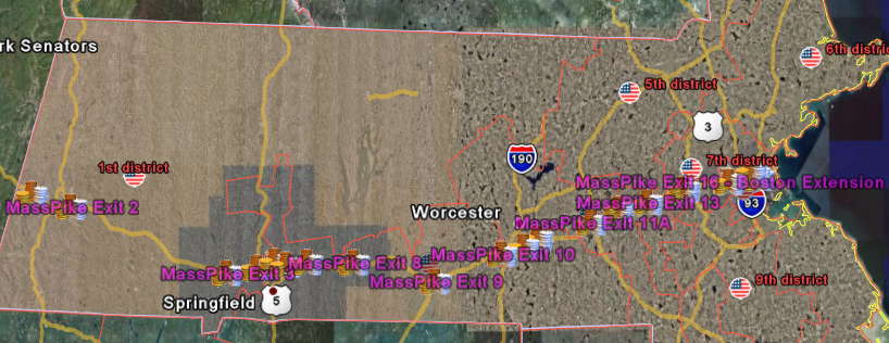
By providing this kind of base data, it allows for anyone to create additional value added products. By displaying this in Google Earth, we can share the shapefiles with users that would never load a true GIS package.
What experience have you had with other States? Perhaps you could share your info in the comments section.
Shapefile Source: Office of Geographic and Environmental Information (MassGIS), Commonwealth of Massachusetts Executive Office of Environmental Affairs
Tuesday, October 03, 2006
Increasing Federal Markets for GIS
The Federal Government has been a huge GIS consumer for years. That’s no secret. They are one of the few agencies that can afford a full deployment of GIS software. But it’s good to see that they are continuing to rely on and emphasize GIS and spatial technology. The “Google Earth Effect” seems to have permeated the newest transportation re authorization bill and other planning doctrines. This new bill requires that visualization takes place during the planning stages of a project. And the bill specifically mentions using GIS to show what the project would look like after it is built.
The FHWA and the FTA recognize that there are myriad ways to use
visualization techniques to better convey plans and programs and there
are wide variations among MPO capabilities and needs, especially
between large, established MPOs and small, new MPOs. States and MPOs
may use everything from static maps to interactive GIS systems, from
artist renderings and physical models to photo manipulation to computer
simulation. Visualization can be used to support plans, individual
projects or Scenario Planning, where various future scenarios are
depicted to allow stakeholders to develop a shared vision for the
future by analyzing various forces (e.g., health, transportation,
economic, environment, land use, etc.) that affect growth.
Tuesday, September 26, 2006
Global Competitiveness Report in Google Earth
Here's another Google Earth file with some current geospatial data. The World Economic Forum has released its 2006/2007 report which attempts to model the process of growth using all the complicated factors that affect countries. The U.S. has slipped. From 1st to 6th based on war and security spending.
If you already have Google Earth installed, check out the data by clicking HERE.  ken@stolasgeospatial.com
Saturday, September 23, 2006
Weekend Video - Man Behind the Maps Part II.
2nd installment of Billy McWilliams doing his part to keep Google Maps up and running.
Friday, September 22, 2006
National E. coli Reported Cases Map in Google Earth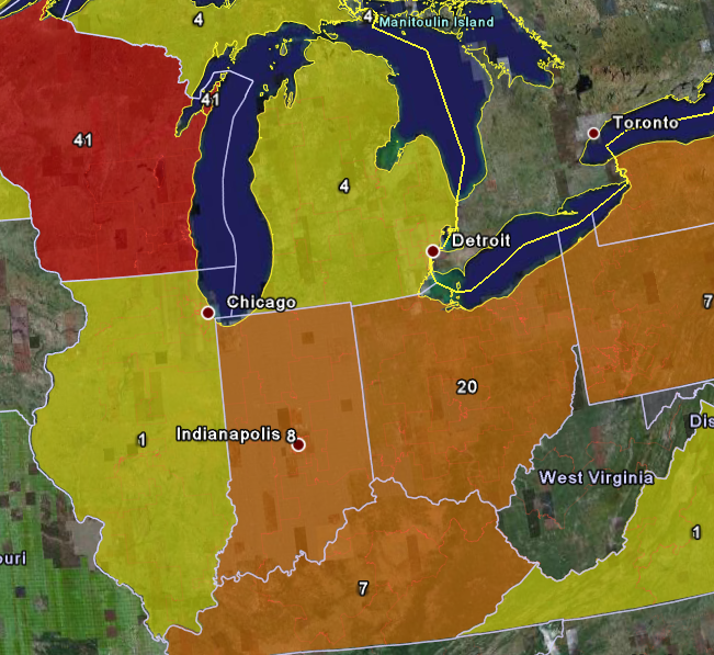
The FDA continues its crackdown on fresh spinach in hopes to bring an end to the current E. coli H157:H7 outbreak. On 9/21/2006 they released the number of illness reports per state.
We've created a simple thematic KML layer showing the number of reported cases per state for a client. Click HERE to open the KML file in Google earth to see the breakdown data (you must have Google Earth installed.)
E. Coli | Spinach | FDA | Google Earth
Wednesday, September 13, 2006
Geographic Spellcheck Strategy
I've grown tired of my Word spell checker constantly showing red underlines on my street names in Office documents. It would take months to type in all the road names into the dictionary if I wanted to use them during spellcheck. Then I realized I had a entire database of street names right in my shapefiles.
So I set out to create a Word custom dictionary in these steps:
1. Save out the road centerline file to DBF.
2. Open the DBF in Excel and delete all the columns but the road name.
3. Save As Tab Delimited.
4. Open in Word and make case changes (if necessary).
5. Copy the data into a Wordpad file. Save with a .dic extention.
6. Load the custom dictionary in Word! Viola!
Now I think I am going to do waterbodies, rivers, railways, airports, etc.....
Tuesday, September 05, 2006
Concept "Maps"
O.K. So these are not true geographic maps, but I think the design can be applied to cartography just the same. Applying some of their principles when presenting Metadata or Schemas would make for an awesome display board.
We develop a range of diagrams and maps to create, test, and refine architectures or organizational structures for the applications and sites we design. Maps created as design tools serve many of the purposes of maps created during audits — creating shared models for the team, uncovering problem areas, and serving as a reference for product managers and engineers.The examples come from Dubberly Design Office, via LifeClever. They are really sharp!

Monday, August 21, 2006
Trimble GeoXT Note
Well today I dusted off my trusty 'ole Trimble GeoXT. Unfortunatly, it's been mothballed since December. Just didn't have any projects for it.
Well when I fired it up it went into some kind of mandatory 15 minute charge up mode. After that, I tried to start up ArcPad 7. Nothing. Couldn't find it anywhere in the system. Well, it took a full re-installation and sync to get back up and running.
Not sure what the technical aspects are of this, but I'll never let this thing get that run down again. Now I'm headed outside (finally - it's 75F and breezy.)