Portable PDF Maps Free Web Seminar
Register here for the seminar.
information, techniques, and news regarding sharing geospatial data across multiple platforms.
Portable PDF Maps Free Web Seminar
Posted by Ken H. at 7:55 AM 0 comments
Geographic Imager - a Photoshop Plug-in
For you photoshop users out there, Avenza Systems has recently released an update to its' Geographic Imager suite. Geographic Imager adds geospatial tools to Adobe Photoshop to allow for manipulating, editing, reproject, and work with geotiffs. Looks like an excellent way to enahnce those aerial photos for special studies. The extention is $599, but there are free trials available for download.
Posted by Ken H. at 11:23 AM 0 comments
shp2text - Export your SHP's to Google Maps
Who isn't looking for an easy way to distribute SHP files to non-GIS users? The guys over at Obviously.com have a real quick way to do just that. Check out their ideas here. Its all based around the Shapefile C Library V1.2.
Posted by Ken H. at 11:42 AM 0 comments
Free WebCast: Pliable Display Technology (PDT) by IDELIX
This free webseminar looks very interesting and could have tons of applications. From their website: Pliable Display Technology (PDT) by IDELIX is an advanced user interface technology that can be integrated into new and existing software applications to improve the way users view and interact with data. Taking the shape of a "virtual lens," PDT provides multi-layer data viewing and data fusion capabilities, allowing users to work with rich, converged content more effectively and with greater ease of comprehension. Available in a Software Development Kit, PDT is easily integrated to enhance existing software applications' toolsets. PDT works on all forms of data from satellite imagery to text and video, and on all platforms from PCs to smart phones. Already proven in applications built for the National-Geospatial Intelligence Agency, PDT can improve the data visualization and interaction capabilities in your software offerings - join the Carahsoft Webcast for a demo.
Posted by Ken H. at 10:21 AM 0 comments
Google Earth Creating a Placemark Tutorial......enjoy while we all wait for ArcGIS Explorer to be released
Posted by Ken H. at 10:10 PM 0 comments

Using Mapdex.org to View Spatial Data with or without ArcGIS
ArcIMS services are great. There are terabytes of data from Iraq, NOAA, and Federal as well as local communities. But you are not limited to only viewing that data from within the IMS site. You can easily add the data you need right in ArcGIS!
It gets even better for those users who don't have ArcGIS, because mapdex will display the information directly into Google Earth.
First navigate over to mapdex.org. There is a good chance you will find something of interest, as the site claims to be:
"A global index of 2,067 servers, serving 37,178 map services, containing
over 400,000 GIS Layers, covering more than 4,000,000 columns"
Once you find your data, click the "layer viewer" icon. A overview window will show a sample of the data and provides an option to display in Google Earth. However, hope it contains a projection - otherwise it cannot be displayed in Google Earth. This is a good place to remind us all about projecting our own data whenever possible. As you will find out, you will find valuable data, only to be frustrated that you cannot display it because it is not projected - it's just good practice to add a projection.
Now, let's bring this same data into ArcGIS. First, jot down the server name. I want to catch up on some locations that Seth and Summer have been this past week in the Fox hit the O.C. So, it's off to Newport Beach, California!
One result comes up. The data I am looking for is at www6.city.newport-beach.ca.us, (the city's IMS site.)
In ArcGIS:
Select 'Add Layer'
In the Lookin Drop Down, 'Select GIS Servers'
Double click 'Add IMS' Server
Paste in the URL from above
After a moment, the server will appear in the window
Click on the data you want in your map and select ok.
You map now has a live connection to the O.C.!
Note: this does not work with sites that require a user login feature, so results may vary.
Posted by Ken H. at 2:10 PM 0 comments
Google PHP Mashup - Hotels for UC
That time is upon us again, and hopefully you have already made your reservations in sunny southern California for 2006 ESRI User Conference. I wanted to take this chance to show an easy Google Map that I made. It really just took the amount of time to type in the addresses of the hotels listed in the back of 2006 UC guide. And then another map was born!
What made it so easy is the PHP script called Phoogle Maps 2.0 by system7designs. Once I uploaded the phoogle.php script, I customized my main page script with just my unique Google API key, and added in the hotel addresses. Thats it! Phoogle Maps uses the Yahoo engine to geocode your addresses, and then plots them on the map on the fly.
I havn't been able to fix the Firefox 1.5 glitch in the info window, as I am not a PHP programmer. But the maps looks great on IE (not that I condone using IE!). There is a noticiable lag while the points geocode. Check it out:
Posted by Ken H. at 12:18 AM 2 comments

GEOSPATIAL21.org Portal
In an effort to increase geospatial awareness, Geospatial21.org is a useful resource for any geospatial professional, however it is geared towards students. Developed by KZO Media with a $1 million grant from the Department of Labor, the site features videos, training modules, and offers a Geospatial Generalist Certificate for those passing a validation exam.
Posted by Ken H. at 9:22 AM 0 comments

ArcDex Tutorial - Display Your ArcMap Data in Google Earth
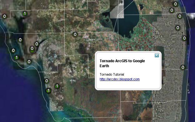
Looking for a free, lightweight ArcMap extention to plot your ArcMap data in Google Earth? This tutorial demonstrates a quick project showing recent tornados in Florida, and just might be your answer.
Download the final product here to skip the tutorial and see the data in GE.
Posted by Ken H. at 2:49 PM 1 comments

Google Maps moves to version 2 (officially)
Google has announced that it has moved over to version 2 today, April 3rd, 2006. Some new features include:
Posted by Ken H. at 1:30 PM 0 comments
New York TV Channel 1 Highlights SmugMug and Google Map-Mashups (video)
Posted by Ken H. at 8:56 AM 0 comments

DataPlace
I just made a couple of maps on the DataPlace.com webpage, and am pretty impressed with the vast amount of free information! They have a wealth of demographic info that can be shown on a map or on a chart, including: mortgage values, high income mortgage applicants by race, types of loans, rental attributes, income and employment, and building permits - to name just a few.
The interface is very similar to that of Google Maps. It is a bit more clumsy, but is easy to navigate and refreshes quickly.
If you are looking to do a free market analysis, this is your site.
Posted by Ken H. at 3:37 PM 0 comments

Census Trax Flash & Google Map
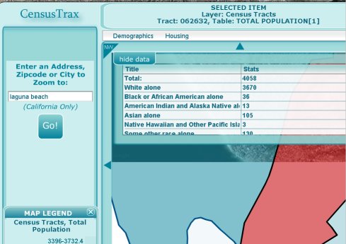
Yesterday, GeoGraphs and Urban Explorer announced the beta release of their CensusTrax application. Using Flash and Google Maps, a mashup is created that displays relevant demographic information in a slick transparent window.
The site is currently in Beta and open free of charge. However, it only features the State of California. There are plans to charge a nominal fee for the service in the future. (editors note...the Google Maps TOS forbids charging for a service that uses google maps, so it will be interesting to watch this develop.)
A description from their webpage states:
"Census Trax is an on-line interactive web GIS service to quickly retrieve, map and export US Census data. It will be available as a very inexpensive on-line subscription service in the near future. For now, while it is still in this beta version, it is freely available to anyone who wants to use it. "
Posted by Ken H. at 10:49 AM 0 comments

GIS Cookbook
The GIS Cookbook is a collection of simple descriptions and illustrations of GIS methods written with minimal GIS jargon. Recipes cover two GIS software platforms, ArcView 3.x and ArcGIS 8/9.x. The target users are social scientists with an interest in introducing spatial thinking into their current research and also having some experience with computers but little to no exposure to GIS. The GIS Cookbook is in its beginning stages and will be expanded to better serve the needs of social scientists.
This is an awesome concept. Using a simple and light interface, the folks over at CSISS.org have step by step tutorials relevant to daily GIS tasks. A great resource.
Posted by Ken H. at 7:40 AM 1 comments
Awesome Google Maps Firefox Extension.
Tools continue to keep popping up everywhere - this one is for Firefox users with the Greasemonkey extension. Greasemap is a user script that resides in your browser and watches for street addresses in the webpages you browse. When it finds one, it instantly plots it onto a Google map in the top of your FireFox browser!
If you have never installed a greasemonkey script before, its easy. First, download the GM script here. Once it is installed come back to this page.
Right Click on the Greasemap hyperlink above.
Select INSTALL User Script.
Lets post ESRI's address here for instant gratification:
Posted by Ken H. at 12:39 PM 0 comments

GEOINT
The Winter 2006 edition of Imaging Notes is out, and features a write up on ArcGIS Explorer from a geographical intelligence standpoint. It shows an excellent example of a vegetation vector layer taken right off of the Geography Network. The article is not directly readable online, but their feature story is.
Posted by Ken H. at 3:13 PM 0 comments

David Maguire has prepared an excellent overview the explains some of the functionality of the ArcGIS Explorer application over at his blog GIS Matters.
A couple of items of interest include:
Posted by Ken H. at 10:41 AM 0 comments
Google Earth has struck up a huge wave of interest in GIS and spatial mapping capabilities. Most users of GE are not yet aware of the tremendous additions the GIS industry is going to add to this new wave in spatial information - but I am sure that ESRI's ArcGIS Explorer is going to change all that.
Market forces are working their magic. ESRI products are superior to most, (and because of that) they are able to charge practically whatever they like for their products. It took a mammoth search engine giant (in Google) to stir the pot a bit in the geospatial industry, and ESRI responded by cooking something free up.
Soon, everyone will be performing spatial queries and analyzing statistics of our own data using ArcGIS Explorer. We'll also be using other's data. The spirit of ArcDex (short for Arc Index, and inspired by MapDex) the theory that we all have shapefiles that can be shared among all users . We all have cool tips, tricks, and hints to make ArcGIS Explorer fun and useful. I hope to feature and catalog as much of this information as possible, to encourage a broad range of collaboration.
Posted by Ken H. at 10:28 AM 0 comments
TuBlog.blogspot.com | Diseño de Free CSS Template | Adaptación a Blogger por Blog and Web