Do Not Pay for Free Data many thanks to Glenn and his GIS Data blog that focuses on where to get free geographic data via the web. It is well organized and a required stop before I start any project. Keep up the great work Glenn!
Sunday, October 22, 2006
Posted by Ken H. at 9:48 AM 1 comments
Friday, October 20, 2006
New! Video Tutorial - Excel to ArcGIS 9.1
Since sending video over the web has not only become extremely simple, but almost the new standard, we've decided to produce our very own ArcDex GIS video tutorials. This first video goes through the steps of connecting an Excel spreadsheet to ArcGIS 9.1. The intent is to help us all appreciate the new Excel functionality in the upcoming 9.2 release :).
I'm not too happy with the way the flash video distorts most of the desktop images. In the future maybe I'll try Quicktime format instead, but for the sake of considering the fact that not everyone has Quicktime installed, let's see how this works out.
Posted by Ken H. at 8:38 AM 3 comments
Thursday, October 12, 2006
Laguna Beach Map Remix

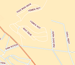
Using Wordsmiths anagram engine I set out to rename a majority of the names of LB streets. While going through these, I found some shockingly relevant phrases coming to light. Phrases relating to the war and tensions in Middle East, for example, Oman Did (Diamond St), Octane Visa (Ocean Vista Dr), Iran Mock Corny (Rim Rock Canyon). And the most sinister phrase I found: Iran Bush GoGo (Gainsborough). Could the secrets of today’s political scene deepest questions lie in the streets of the Real O.C?
I was also amused by some of these: Blue Bird Canyon is an anagram of Crabby Oiled Nun, while Canyon Acres could Scare Any Con(servative?) perhaps?
A full version in PDF format can be downloaded here (its big - 36x48)
Download the shapefile for the remixed roads here (zip file, remixed names are in field N9)
Note: Some phrases may be objectionable to some readers. Keep that in mind.
Posted by Ken H. at 10:49 AM 0 comments
Tuesday, October 10, 2006
Maps of War: 3000 BC to 2006 AD
I didn't really pay to much attention to European History in High School. So I'm thankful for this quick review from the Maps of War Imperial History video.
I am really hoping that the ArcGIS 9.2 release can handle this kind of video as well.
Posted by Ken H. at 11:25 PM 2 comments
Friday, October 06, 2006
Using Google Code Search for ArcGIS
Google Labs has recently announced the unveiling of its' newest creation - Google Code Search. Code Search indexes publicly available code - which is then available to you via their search engine. This should be very helpful for all you custom programmers out there.
I tried out the simple query of ArcGIS and got back a couple of interesting results. One of which being a Python script for exporting the ArcGIS table out to mySQL. Right above that result was a script written in C that creates cartograms.
Have any better ideas or search strings that will maximize the use of Google Code Search in GIS? Please share them in the comments section.
Posted by Ken H. at 9:55 AM 1 comments
Wednesday, October 04, 2006
Massachusetts Tollbooth Locations in Google Earth
One of the best government GIS sites has to be the State of Massachusetts MassGIS portal. They have a ton of shapefiles for almost anything you could need, plus building footprints for the city of Boston. Here is a Google Earth KML we file created from the MassGIS 'Tollbooth' layer which shows the locations of interstate tollbooths in the Bay State. 
By providing this kind of base data, it allows for anyone to create additional value added products. By displaying this in Google Earth, we can share the shapefiles with users that would never load a true GIS package.
What experience have you had with other States? Perhaps you could share your info in the comments section.
Shapefile Source: Office of Geographic and Environmental Information (MassGIS), Commonwealth of Massachusetts Executive Office of Environmental Affairs
Posted by Ken H. at 11:55 AM 0 comments
Tuesday, October 03, 2006
Increasing Federal Markets for GIS
The Federal Government has been a huge GIS consumer for years. That’s no secret. They are one of the few agencies that can afford a full deployment of GIS software. But it’s good to see that they are continuing to rely on and emphasize GIS and spatial technology. The “Google Earth Effect” seems to have permeated the newest transportation re authorization bill and other planning doctrines. This new bill requires that visualization takes place during the planning stages of a project. And the bill specifically mentions using GIS to show what the project would look like after it is built.
The FHWA and the FTA recognize that there are myriad ways to use
visualization techniques to better convey plans and programs and there
are wide variations among MPO capabilities and needs, especially
between large, established MPOs and small, new MPOs. States and MPOs
may use everything from static maps to interactive GIS systems, from
artist renderings and physical models to photo manipulation to computer
simulation. Visualization can be used to support plans, individual
projects or Scenario Planning, where various future scenarios are
depicted to allow stakeholders to develop a shared vision for the
future by analyzing various forces (e.g., health, transportation,
economic, environment, land use, etc.) that affect growth.
Posted by Ken H. at 10:15 AM 0 comments